Driving The Alaskan Highway
A long stretch of highway, traversing through the Yukon Territory, and miles of wilderness to reach The Last Frontier. We knew very little about this highway in 2017. How were the roads? Were they paved? Can you even drive the entire way to Alaska?
Five minutes and a google search later, "Of course we can drive it”. As soon as the idea was planted we couldn’t wait to take our Alaskan adventure..
Our greatest adventure.
We’ve made many road trip memories since Alaska, but none have been as intense, entertaining, new, or just plain amazing as this drive. Some fear of the unknown also played into this lasting impression.
Don't take our word for it. If you are considering this drive, maybe our experience will encourage you to take a chance and make memories of your own. We don't know everything there is, but included are our stops, favorite attractions, and what to expect while on the road.
You can follow up with our other posts if you haven’t already.
how do I plan my stops?
For Gas
We read people have carried spare gas cans in fear of running out of fuel; we even carried one ourselves. This was more common early in the Highways history, however since then it doesn’t seem to be required. We found most stations were approximately 200-300 miles apart. Likely you won’t require extra gas, but it is important to fill up/top off your tank whenever possible. Even more important in late fall/winter. Many stations are closed for the winter season, leaving only the larger towns and select local stops available. Some of the small/local gas stations have shorter winter hours and are closed at night. Stay on the safe side and top off, no matter how much is left in your tank.
For Hotels
Our drive to Alaska was in late October 2017 and everything we read recommended basing our drive around daylight hours. Mostly for safety.
There can be wildlife in the road and you do not want to strike a bison due to poor visibility.
There are more cars driving on the road during daylight. Even then, you may only see a few your entire day.
We strategically picked our hotels based on what we thought was an average daily mileage to cover. We used google maps to determine total drive time, then added an extra 2-2 1/2 hours to that total. This accounted stopping for lunch and planning ahead for poor road conditions.
This was most important during fall because some mornings, just before dawn, the roads were difficult to see. We allotted extra time for driving below the speed limit, allowing for sight seeing, taking pictures of animals, or taking it slow on icy roads.
our caravan
We drove both our vehicles (chevy 1500 & Equinox) to Alaska and back. For each trip, we had family who were willing/excited to make the drive with us. Special thanks to Karyl and Roger (Kari’s parents) for driving to Alaska, and to Roy (Tyler’s dad) and Roger (Kari’s dad) for joining on the trip back to the lower 48. Not only did this make the trip that much more memorable, but we had the benefit of two cars incase one had any issues. And to add, Roger (Kari’s dad) in his mid 60s, refused to let Kari drive because he wanted to say he drove the entire Alaskan Highway!
Sharing the drive with family was our favorite part. Long stretches of road to talk, seeing country and wildlife that we had never seen before, and making new memories along the way.
Where we begin: crossing into canada

The only way to drive to Alaska is through Canada. The Alaskan Highway was built during WWII as a way for the contiguous United States to connect to Alaska through Canada.
The Official Start of the Alaskan Highway is Dawson Creek, British Columbia
The Official End of the Alaskan Highway is Delta Junction, Alaska.


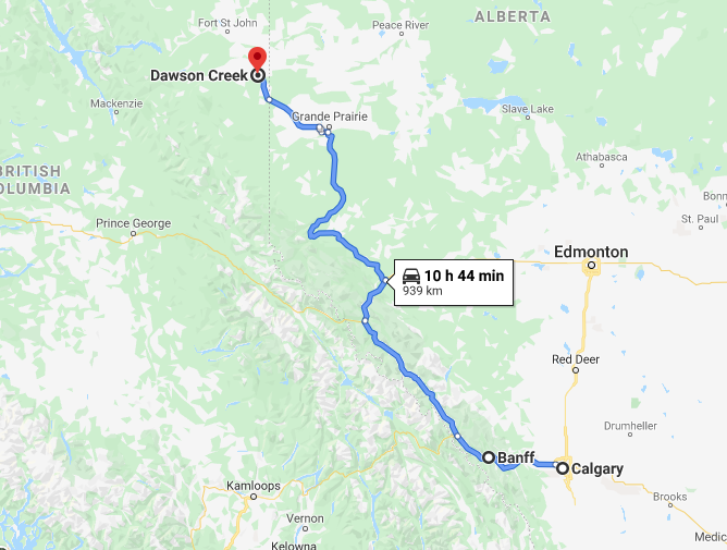
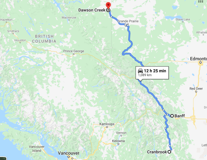
As you prepare for your drive to Alaska, you have a few choices prior to officially arriving at Dawson Creek. You can opt to drive up to Calgary, and continue your route just west of Edmonton (outlined by map on the left, click to enlarge) This route has longer stretches of highway and can be “easier”. Option two would be hanging a hard left from Calgary and driving through Banff and Jasper National Park, even stopping to see Lake Louise (outlined by map in the middle, click to enlarge). Lastly, if you are coming from the Western states, you may be able to skip Calgary all together, going through Cranbrook, and heading straight up to the National Parks (outlined by map on the right, click to enlarge).

We weren’t about to drive this once in a lifetime adventure without seeing Banff or Jasper National Park. Therefore, driving from CA, we crossed into Canada at the Eastport entry, north of Coeur d'Alene Idaho. Our first stop for the night was just a short drive from the border; Cranbrook, BC. The perfect starting point for an adventure through several Canadian National Parks.
A QUICK BLURB ON CROSSING THE BORDER
We had to surrender our pepper spray to the “Queen”. Honestly, we didn’t know we couldn’t bring pepper spray through, but once cleared we did think it was funny that the “Queen” now has it.
Also, for those bringing pets, don’t forget it’s not just you who needs a passport. Your pet will need a current rabies vaccination and health record signed by a vet. They didn’t check our paperwork, but it clearly states online that you need to have one. Don’t get turned around before you even start your journey.
Day 1: Best Western in Cranbrook, BC to Tonquinn inn: Jasper, AB
There are a number of hotels in Cranbrook to choose from, just be sure to check ahead for reservations. We chose a Best Western, but a quick google search will show plenty of other options. From here you begin a beautiful drive through Banff and Jasper National Parks.
Consider planning a stop for lunch at Lake Louise. We parked, made a few sandwiches, and explored the lake. (click images to enlarge)


Keep in mind, as you travel into the National Parks, check weather reports. Some of the roads may be closed due to heavy snowfall in late fall, winter or early spring.
As you leave Banff and Lake Louise, you may have some challenging roads pending weather conditions. You can see from the picture below that as life long Californians, we were adjusting to our new normal of driving in snow.

Little outside our comfort zone!
Next stop before Jasper National Park is the Columbia Icefield Discovery Center. Here you can park and see the beautiful Athabasca Glacier. If you have extra time and are adventurous I would consider taking the bus tour onto Athabasca Glacier and the Skywalk. Click here for their website. Just a disclaimer, in our October drive, none of these activities were available, and in June, we didn’t have time due to having to drive from Alaska all the way to Louisiana. We thought the adventure looked fun, but don’t have personal experience with this company. Seeing this place in fall was adventurous enough! (click to enlarge images)


Arriving in Jasper, AB for the night, we stayed at the Tonquin Inn during our drive in October. Lovely hotel, not the fanciest, but a good price and had an outdoor hot tub. Perfect after a long day of driving. If you read our previous post, you already know that on our drive back down to the lower 48, the Tonquin Inn, along with every other hotel was booked. Our only option was Chateau Jasper. A beautiful hotel, but no continental breakfast and extremely costly. Book ahead! Always book ahead!
If you arrive early enough, consider strolling through the streets of Jasper. It is a beautiful town with good local pizza parlors, multiple gift shops and dinning options.
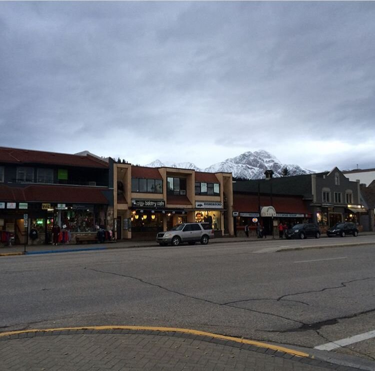
Downtown Jasper
day 2: Jasper ——> Grande Prairie, AB (super 8)
From Jasper to Grande Prairie, aside from beautiful countryside, we didn’t make many stops. This section of the highway has winding roads, but relatively an uneventful day. We enjoyed a day without snow as well as arriving to our hotel after only 6 hours on the road.
Arriving in Grande Prairie you might notice it’s a bigger town than expected at a population of over 60,000 people. We chose this Super 8, they had availability, it was pet friendly and had ample parking for two cars. There are numerous hotels and food options available, so stock up if your ice chest needs filled before you head out to your next destination.
day 3: Grande Prairie ——> fort Nelson (super 8)
This is it, today is the day you officially “START” driving on the Alaskan Highway. A short 1 1/2 hours from Grande Prairie and you arrive in Dawson Creek. This was the day of the dreaded snow storm. If you haven’t read our post on preparing for the Alaskan Highway, I’ll summarize our mishap here. An unexpected storm came the night before we were to arrive in Dawson Creek, leaving over 8 inches of snow. One of our cars was not prepared with proper snow tires and we couldn’t go any further safely. Panicked, we found a Chevrolet dealership that might be able to help. Despite being peak season for mounting snow tires, they had our size in stock and were able to squeeze us in within a 2 hour window. After a few hours in Dawson Creek we were back on the road!
The reason I look so happy in the photo below is because it was taken after our tires were on and we were ready to head out! Having spent extra time on tires, looking for snow boots in a local Walmart and stressed about having to likely drive well past sunset, we didn’t even realize there was an actual “Mile Marker 0”. Luckily we had the opportunity for this photo on the return drive. (click images to enlarge)


Once you have all your photos of the Alaskan Highway sign and “Mile Marker 0” be sure to top off as it’s about to get rural! Our stop tonight is another Super 8 in Fort Nelson, BC.
The rest of the drive felt long as we spent several hours in Dawson Creek.
Oh yeah, up to this point I forgot to mention that the Alaskan Highway is notorious for cracking windshields. Alaska too for that matter. A semi truck decided we were going too slow and passed us throwing a few pebbles our way. Total on the drive I counted 3 “fairly small” cracks to the trucks windshield. The equinox never had an issue. Thank goodness.
Despite all this, we were having the time of our lives! Exhausted upon arriving, we couldn’t have picked a better hotel for the night. Literally, within the same parking lot as a restaurant called Boston Pizza. I have no idea if it even tastes close to Boston style pizza, but perfect for the weary traveler. Grab yourself an ice cold beer and pizza, walk back to the hotel and get some rest.
Day 4: FORT NELSON ——> Watson Lake (big horn hotel)
To recap a little, thus far you have seen Banff National Park, Lake Louise, Jasper National Park, Athabasca Glacier, and the official start of the Alaskan Highway. Everyday provided something new to see and this day was no different.
After heading out from Fort Nelson, your first expectation of the day should be wildlife sighting. A few hours north and you will pass Muncho Lake. This is a great corridor for northern wildlife sightings! (click images to enlarge)
HAVE YOUR CAMERA READY


If that wasn’t enough, in just a few short hours, you will reach Liard River Hot Springs. Have your swim suit ready! After long days on the road this is a great spot for lunch and relaxation. There are separate changing rooms as well as bathrooms at the springs. Once parked, it’s just a short stroll along wooden planks to reach the hot springs. We made this a stop in fall and summer. In the winter, it was free to park and much less crowded. In summer, starting April 1st, it is 5$ to enter (I believe cash only). (click images to enlarge)


After enjoying your time at the hot springs, there is one final stop before you reach your destination this evening. Between the hot springs and Watson lake, you will cross into Yukon Territory. Don’t forget your picture. There are technically two signs. The first you come across is an old white sign with a bunch of stickers and writing on it. We took a picture in front of it, unsure if we would see anything better up ahead. Well, that first sign will be your warning to keep eyes peeled for the “official sign”.

Yorkie, meet Yukon!
Arriving just after sunset with a little snow fall, we pulled into our hotel; the Big Horn Hotel. Lovely place with extremely friendly staff. Literally right next door is another hotel A Nice Motel, which we did not stay at, but read good reviews prior to our trip as well. There is a gas station immediately to the right of the hotel. You can fill up before calling it a night.
If you are hungry, we tried Andrea’s Restaurant , it is immediately to the left of the hotel. Was it the best food? No, but it wasn’t bad and really the only option this time of year. Again, I’m not a foodie, and my food recommendations are taken with a grain of salt. I think the funniest part of the night, with everyone being exhausted, was when Roger (Kari’s dad) walked out of the bathroom and said “they have souvenirs for the taking”. Come to find out Andrea’s has free condoms in the restroom. CLASSY.
Depending on what time you reach your destination, you do have something very cool to see while staying in Watson Lake. Whether it is in the evening, or the next morning, I would check out the Sign Post Forest.
Starting in 1942, a GI was repairing directional signposts and added one of his own, listing the mileage and direction to his hometown. Several others followed suit and the Sign Post Forest was born. According to yukoninfo.com visitors can bring their own sign or make one at the visitor center to add to the forest.

day 5: Watson lake ——> Haines Junction (alcan motor inn)
The stretch from Watson Lake to Haines Junction is absolutely beautiful, but we didn’t do much else other than drive. The town of Whitehorse is on the way and has several gas stations as well as fast food and restaurants. We stoped for a burger, but unfortunately don’t recall the name of the restaurant.
Whether it was in October or June in Haines junction, the backdrop to the small town was gorgeous. Stunning snow capped mountains that are so close you feel like you could reach out and touch them. In October, there weren’t many hotels available, and the Alcan Motor Inn was pretty much it. Despite it’s outward appearance, we slept GREAT! At this point on the drive we actually began to recognize cars and people who were making identical stops as us, almost like a caravan. I don’t remember much being open in October, other than a shell station as you enter town.
In June, this was a different story. We took a walk around several blocks, enjoyed a small bus converted to a pizza kitchen with outdoor seating and a local band playing at a nearby bakery/ice cream shop.
day 6: Haines junction ——> Tok, Alaska (caribou cabins)

Waking up in Haines Junction, walking out of your hotel room, the first thing you see are the mountains surrounding the town. Stunning! Take in a deep breath as today is the day you finally say hello to The Last Frontier. Today’s drive is scenic, but there is only one real stop worth seeing, the Welcome to Alaska Sign.
I don’t have much else to say, other than have your passports ready for border patrol, and enjoy entering Alaska as you head on to Tok.
We stayed at the Caribou Cabins, just a mile outside of town. They only have a few cabins, but if available, these are awesome, sleeping between 4-6 people. The owners have a breakfast nook attached to the main house with bagels, cereals, and other snacks. Just behind the house is their pet caribou! Yes, for real! We enjoyed it so much, we chose to stay during our return trip as well.

If no vacancy, look into the Mooseberry or Youngs Motel. Both were listed as alternatives when we did our research into Alaska.
Lastly, if you’re hungry, stop by Fast Eddy’s. Nice diner in the middle of town, and pretty good food. Even Kari thought it was good (she is picky!)
day 7: TOK, AK ——> soldotna, AK
Kari is telling this section:
The scariest storm I have ever driven in. Literally white knuckling the steering wheel. I decided I would drive today to give Tyler a break and of course we would hit a major snow storm driving through a pass. Within just a few minutes I swear the roads were covered as we went over the last pass of the drive. It was near whiteout conditions and trucks were right behind me going fast. Good thing I couldn’t see to the left over the cliff, because I thought it was just a few feet drop. When driving back in June, come to find out we were several hundred feet up without any guard rail. Tyler was helping me down shift manually because I was too scared to take my hand off the steering wheel.
After what seemed like hours, we were out of the mountains and it was only a slight rain in Palmer Alaska. I made a pit stop for some Taco Bell! (you can only find A&W in Canada, and it’s everywhere). At this point, I needed a nap, and Tyler took over.
With just a few hours until we reached Soldotna we headed past Anchorage, through the Turnagain Arm, and were stunned by the massive mountains meeting the sea.
Passing through what was labeled as (small) towns, with really only a building here and there, knowing we were nearing Soldotna I hear Kari say “I don’t care how much money we have to take from our savings, we are taking it and driving home!” We thought we had reached our town and there was nothing but a bar named Moosequitos. At this point it was pitch black, no street lights and no signs of a town for over an hour or two. It was quite rural. We kept driving, slowly, eventually turning a corner and being greeted with a Fred Myer, Sportsmans Wearhouse and Safeway. Beautiful lights of a small city.
Relief!
We hit a dirt road, nervous for our first rental on a travel assignment and reached our home for the next 7 months. The walkout basement we rented from two local Alaskans who were once travel nurses was the most welcoming sight. We couldn’t have felt more at home! Here is too our 7 month adventure we were about to have!

Kari’s dad cooking us some food after arriving in Alaska!
Related Posts


